


Girraween (The Place of Flowers) National Park
- B-Line Bruce Hiscock
- Feb 26, 2018
- 9 min read


Activity Description
Family camping trip
Loads of hiking
Location
Girraween National Park

Getting There
Girraween is an easy country drive along bitumen roads: Turn off the New England Highway 26 km south of Stanthorpe or 11 km north of Wallangarra, then continue east for 9 km to the Girraween visitor information centre. Stop at Girraween’s information centre to find out more about the park and what you can see and do when you visit (see map below).
Park Features
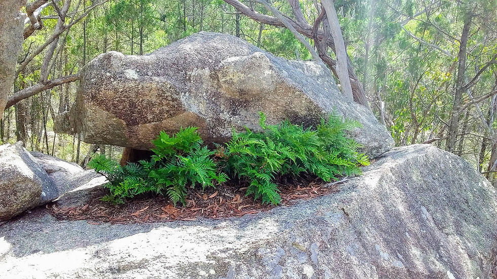
For me, Girraween National Park is a truly special place. What the camping areas lacks in playgrounds and man-made entertainment for the kids, it more than makes up for in natural granite formations to climb and explore. There are enough shorter walks close to the camp grounds, to keep the young ones busy, and even a swimming hole to take a dip in. Our children spent hours climbing over the granite ridge located right beside the camping area, with their newly made friends. Just let the kids go free range, they’ll love it.
The camping facilities are perfectly adequate to make the camping experience on the pleasant side of roughing it. The warm showers in the daily cleaned amenities block are very welcome after a day of bush walking.
There is a variety of walks, with varying lengths and intensities (see tables 1 and 2) to cater for the less experienced and fit, through to the seasoned hiker with a moderate to high level of fitness.
On this camping trip with my family, we walked and climbed, Castle Rock, The Pyramid, and even pushed a pram into the Dr Roberts Waterhole and the Underground Creek (although there were a lot of stairs to negotiate on the later). Our older children loved the climbs!
In winter it can get unbearably cold at night, with the mercury plummeting to the negative regularly. Summer is very hot in the daytime, while the nights were comfortably brisk. So, plan your trip wisely. Remember, the wild flowers put on quite a show during the springtime.
Longing for a nature escape? Wander past imposing granite outcrops, around amazing rock sculptures, into hidden crevices or relax by a rockpool. Climb to a peak and feel like you’re on top of the world! Delight at a myriad of feathered, furred or scaly creatures, and delicate wildflowers splashing colour among the granite in spring. Girraween is an Aboriginal word meaning ‘Place of Flowers’ and its changing seasons will lure you back time and time again.
From easy Wyberba walk to a challenging full day hike to Mount Norman and back, it takes more than a couple of days to explore Girraween’s 11 800 hectares of rock-strewn ridges, cascading creeks and fascinating forests.
Thrill at seeing The Pyramid or hiking up it for the first time. Stand in awe under Granite Arch. Delight in discovery along the creek or between boulders on the Bald Rock Creek circuit or The Junction track, where enticing rockpools beckon you to dip in your toes or watch reflections in still, chilly waters. Simply disappear! Underground Creek will amaze as water mysteriously vanishes and then resurfaces to continue its journey downstream to Dr Roberts Waterhole. Get your blood pumping on a longer hike to imposing Castle Rock, The Sphinx or Turtle Rock, where you’ll gaze over rugged scenery formed by molten rock that has been uplifted, exposed and eroded by water, wind and ice. Be transported into Girraween’s remote ‘back country’ when you visit Mount Norman day-use area, cycle or walk shared trails, or take on the challenge of an overnight hike. https://www.npsr.qld.gov.au/parks/girraween/pdf/girraween-dg.pdf
Facilities
Castle Rock camping area
Pitch your tent in open grassy areas of Castle Rock camping area.
Camping area features: Castle Rock camping area has semi-grassed and semi-shaded sites suitable for tents, camper trailers, caravans and motorhomes. When booking, you must choose either a tent or camper trailer/caravan site. Sites are not numbered and available on a first come basis.
Location: Castle Rock Creek camping area is situated 100 m from the QPWS information centre, on the southern side of Pyramids Road.
Access: Castle Rock camping area can be reached by conventional vehicle. It is accessible for trailers, caravans and buses. In some cases, it is not possible to park near your tent site.
Tent sites: tent sites are in an open, semi-grassed area with vehicle parking around the perimeter. This camping area is more suited to larger groups than Bald Rock Creek camping area.
Camper trailer/caravan sites: twenty-five dedicated sites are available for motor homes, campervans, caravans and camper trailers only. Tent sites are available adjacent to the trailer sites. Some sites allow full sun for greater solar power availability.
Camp site surface: hard decomposed granite soil, dirt, grass.
Facilities: hot showers, toilets, picnic tables, water (treat before drinking) and communal wood barbecues. The Castle Rock camping area amenities block has wheelchair access. As rubbish bins are not provided you must take your rubbish with you when you leave. There are no powered sites.
Open fires: permitted in QPWS barbecues only (except when fire bans or prohibitions apply). Fires should not be left unattended. Fuel stoves are recommended. Bring your own cleaned, milled firewood if you want to use the barbecues. Never collect wood from the bush. All barbecue ashes need to be disposed of appropriately (wet down and take to waste transfer station). Ash must not be dumped in the camping area or bush.
Generators: not permitted.
Essentials to bring: drinking water, rubbish bags (no bins are provided), insect repellent, fuel or gas stove in case of wet weather, warm clothing and warm bedding. Read more about Things to know before you go.
Bookings: book online. Book up to 12 months in advance.
Mobile phone coverage: not available.
Bald Rock Creek camping area
Most campsites in Bald Rock Creek camping area are tucked away in the bush.
Bald Rock Creek camping area has sites suitable for camper trailers, but not for caravans.
Camping area features: Bald Rock Creek camping area has semi-grassed and semi-shaded sites suitable for tents and camper trailers. When booking, you must choose either a tent or camper trailer site. Sites are not numbered and are available on a first come basis.
Location: Bald Rock Creek camping area is situated 120 m west of the QPWS information centre on the northern side of Pyramids Road.
Access: Bald Rock Creek camping area can be reached by conventional vehicle and is not suitable for buses, caravans and motor homes.
Tent sites: tent sites are either individual sites or in an open semi-grassed area with vehicle parking around the perimeter.
Camper trailer sites: 8 dedicated sites are available for camper trailers only. Some sites allow full sun for greater solar power availability.
Camp site surface: hard decomposed granite soil, dirt, grass.
Facilities: hot showers, toilets, picnic tables, water (treat before drinking) and wood barbecues. As rubbish bins are not provided you must take your own rubbish with you when you leave. There are no powered sites.
Open fires: permitted in QPWS barbecues only (except when fire bans or prohibitions apply). Fires should not be left unattended. Fuel stoves are recommended. Bring your own cleaned, milled firewood if you want to use the barbecues. Never collect wood from the bush. All barbecue ashes need to be disposed of appropriately (wet down and taken to waste transfer station). Ashes must not be dumped in the camping area or bush.
Generators: not permitted
Essentials to bring: drinking water, rubbish bags (no bins are provided), insect repellent, fuel or gas stove in case of wet weather, warm clothing and warm bedding. Read more about Things to know before you go.
Bookings: book online. Book up to 12 months in advance.
Tracks and features for cycling and walking
For ease of reading I have included two tables of the trails, tables 1 and 2. These include: trail name, its class, distances (some are return and some are one way) and walking times.
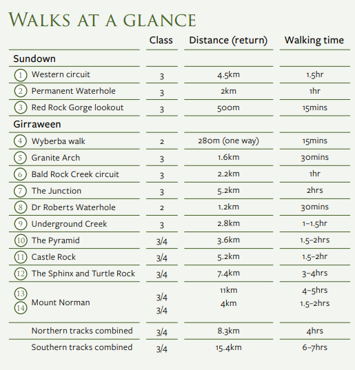
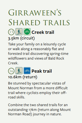
Table 3, is of the grading system for walking and mountain biking.

WARNING!!!!!!!!!!
Before undertaking an adventure activity, realistically consider your group’s fitness level, the trail difficulty rating, weather conditions and the daylight time you have available. It gets hot as hell with the heater on in summer, so, insure you have adequate water (1 litre per hour per person) try to plan your activity for the cool of the early morning, and take enough food and/or energy gels. In the cooler months it gets very cold, so consider warn clothing. Also, consider the wind conditions as some of these climbs are open faces and can be dangerous in high winds.
Authors note: It was crossing these open faces with my two young children that gave me approximately 50 mini heart attacks and shortened my life span by 10 years.
More information and printable maps can be found at the following link: https://www.npsr.qld.gov.au/parks/girraween
Story time
Day 1
We arrived at the camping grounds at around midday, having taken our time traveling from Brisbane, stopping off at Warwick and Stanthorpe along the way. The children wasted no time in disappearing into the bushland, and climbing the ridge located right beside the camping area.
Later in the afternoon we all took a walk to the swimming hole and had a very refreshing dip.
Then an early dinner and star gazing till bed time.
Up on the ridge
On the ridge

The swimming hole

Day 2
Day two, saw my daughter and I take on the Castle Rock walk early in the morning, 5.2km return. It is a fairly easy walk until the bottom of the hill. From here it is a case of climbing the stairs until you go through a thin pass, out onto the open face, and up to the very top.
Afterwards we took a drive into Stanthorpe to grab some extra supplies. It turns out that Stanthorpe is a fairly short drive, making it handy when picking up those extra or forgotten supplies.

And the climb begins

The pass through to the open face
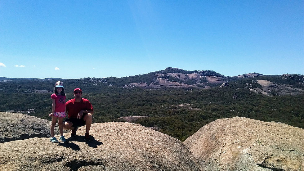
Mt Norman in the background

A view to The Pyramid
Day 3
Day three was a quiet down day, we let the kids go crazy on the ridge with the new campsite friends until the afternoon.
Later in the day, after the heat of midday had passed, we took a short drive to the trail head carpark for to explore the trails for Dr Roberts Waterhole and the Underground Creek. The former trail being easy to take the pram down, the later however, had a lot of stairs to drop down at the point of not wanting to return having already walked so far.
The waterhole was very picturesque if not swimmable, much to the disappointment of the kids.

Dr Roberts Waterhole
It became apparent that the underground creek was once an above ground creek, that over billions of years had cut through the granite rock, then the cliff face had collapsed over the creek, turning it into the underground creek. Again, two unhappy faces on our children, with nowhere to swim.

So, we explored a little, and found a trail that lead around and up to the top of the underground creek. Here we found the creek and where it spectacularly descended a gorge into the underground section. Here, we climbed down into a pool for an exciting swim (mum would not have permitted this had she of been there). Unfortunately, I left my phone at the pram and did not get to take any photos.
We also got to see a flock of yellow tailed cockatoos flying in this area.
Day 4
Another early morning start after breakfast we headed off to climb The Pyramid. This was one of the scariest experiences of my parenting time. I was so scared that my blaze kids would slip and tumble down the open cliff face. They were so excited by it all that they appeared to be completely unaware of the potential danger. My daughter said, “daddy, you are crushing my hand”, on more than one occasion.
All said and done we had a wonderful experience, with the kids loving every second of it. The views were spectacular as always here.
The Pyramid is a 3.6km return walk. The first section through the Granite Arch is very mellow. It is when you get to the bottom of the hill, and the trail starts to climb many stairs that the grading changes. From here on it can be a little demanding, especially for the younger ones. The open face scramble is not too bad as it follows some rock formations for most of the way, providing a sense of security. The top section does come into the open however, and this was where daddy had his kittens. But it is still easily passed.

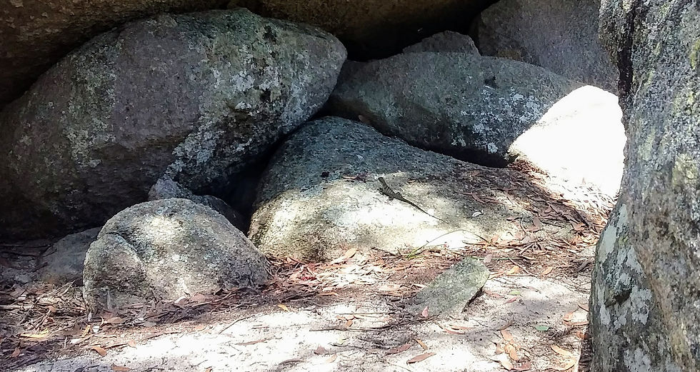
The solar skink

That's where I left it
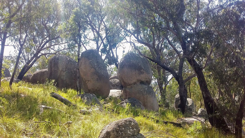
The formations are spectacular
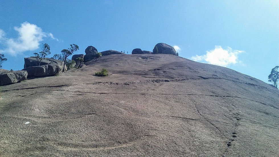
Follow the white dashes up

Balancing Rock

The old lava flow
Day 5
Crying day. Time to pack up and go home.


Comments