


8 WATERFALLS IN ONE DAY
- B-Line Bruce Hiscock
- Mar 7, 2018
- 6 min read


Activity Description
Hiking
Location
Springbrook National Park (Gold Coast Hinterland), Queensland, Australia
Getting There
From the Pacific Motorway, Springbrook plateau is 24km from Mudgeeraba or 36km from Nerang. Exit the Pacific Motorway at Mudgeeraba (exit 79 from the north, exit 80 from the south) and follow the Gold Coast–Springbrook Road. Alternatively, exit the Pacific Motorway at Nerang (exit 69) and follow the Nerang–Murwillumbah Road for 23km then take the Springbrook turn-off at Pine Creek Road. Both bitumen roads are steep, winding and narrow.
Note: There is no through-road access to New South Wales from the Springbrook plateau.
Important! Please read the Park Alerts for current road closures. A detour map for the Gold Coast-Springbrook Road (PDF, 1.1M) shows alternative road access to the plateau.
Park Features
Overview
Springbrook National Park has been declared by UNESCO as a World Heritage Area and is recognised as a part of one of the world's most outstanding and valuable places. It makes up one part of the Gondwana Rainforests of Australia that cover the Scenic Rim (including nearly all of Lamington and Springbrook national parks and most of Main Range and Mount Barney national parks) with the listed rainforests of northern and central New South Wales.
The Gondwana Rainforests include the most extensive areas of subtropical rainforest in the world, large areas of warm temperate rainforest and nearly all of the Antarctic beech cool temperate rainforest. http://www.environment.gov.au/heritage/places/world/gondwana
Although the total area of Australia's remnant rainforest is small on a global scale, its value to the world is immense. In the past 200 years, three-quarters of Australia's rainforests have been destroyed or degraded. However, Gondwana Rainforests of Australia World Heritage Area conserves a rich diversity of wildlife, including more than 1700 species of flowering plants and 500 vertebrate animals. Protecting these areas in national parks or other reserves ensures this biological diversity is secure. It also allows natural processes such as evolution to continue, undisturbed by human influence.
With pride, we protect and present this heritage—the world's heritage. Help us ensure that while we enjoy this wonderful area, we do not destroy it. Please look then leave—without a trace. https://www.npsr.qld.gov.au/parks/springbrook/culture.html
Flora and fauna
Ancient Flora
Antarctic beech Nothofagus moorei, relics of an earlier cooler, wetter age, now occur only at high altitude. Visit the cool temperate rainforest on the highest part of the plateau at Best of All lookout to view some of these ancient trees—some are around 3000 years old. https://www.npsr.qld.gov.au/parks/springbrook/culture.html
It’s astounding to think how long Southern Beech trees (Nothofagus spp.) have stood. The reported age of some living trees is thousands of years; relics from before the time of the Egyptian pyramids.
Southern Beech trees evolved millions of years ago on the mega-continent Gondwana while dinosaurs still roamed. When Gondwana broke apart to form most of the earth’s Southern land masses, the trees moved with them. https://hillstoheadlands.com.au/antarctic-beech-trees/
Fauna
If you managed to walk quietly you may get to see some of the animals living in the park of which there are:
Mammals and nocturnal animals
· Pademelons (small rainforest wallabies)
· Brushtail and ringtail possums, sugar glider or large greater glider
· Koalas are occasionally seen on the drier western ridges of the plateau and in the open forest areas of Numinbah section
· Vulnerable spotted-tailed quoll, mainland Australia’s largest native marsupial carnivore
Birds
· Yellow-tailed black cockatoo
· The slender brown cuckoo
· Albert's lyrebird
· Yellow robin
· Rufous fantail
· Superb fairy-wren.
· Three species of rosella
· The black and gold regent bowerbird and the larger midnight-blue satin bowerbird

Reptiles and amphibians
· Lace monitors
· Glossy black skinks
· Carpet pythons
· Blue spiny crayfish
· Eels
· Orange-eyed treefrogs and Great barred-frogs
· Long-finned eels
· Platypus
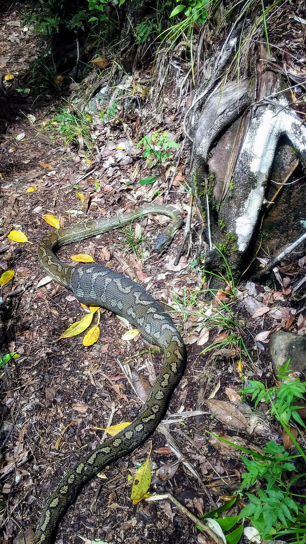
Carpet Python
Hike description
Warrie circuit (Grade 4)
DANGER: Sheer cliffs and waterfalls. One slip could be fatal—serious injury or death may result from walking near the edge. Keep to the track. Supervise children closely.
Distance: 17km return
Time: Allow about 5 to 6hrs walking time
Caution:
· Natural creek crossings may be impassable after heavy rain. Allow enough time to finish the walk in daylight hours.
· Some sections of the circuit may be excessively overgrown; hazards such as fallen trees and rockfalls likely to be present. Exercise caution when walking.
Details: Start at Canyon lookout or Tallanbana picnic area. The longest and most interesting track on the plateau follows the base of The Canyon cliffs to Goomoolahra Falls before descending into the mossy green depths of the rainforest. The track (named with the Aboriginal word 'Warrie', meaning 'rushing water') crosses several creeks and gullies. The track reaches the 'Meeting of the Waters', where all watercourses dra
ining The Canyon meet, then climbs up the western side of the gorge. The moist and shady conditions at the base of Goomoolahra Falls provide an ideal habitat for the giant spear lilies Doryanthes palmeri. This succulent herb is one of only two members of the Doryanthiacea plant family, which is endemic to Australia. (see map below)

Story time
The day started out very eerily, with the entire area shrouded in a thick fog, and after some early morning logistical confusions we managed to get it together and get going to our destination. It was intended to be at Canyon Lookout for the sunrise. But, given our confusions and having to stop on the way to take photos off of the bridge on the Nerang Murwillumbah Road where it crosses the Hinze dam, we had to settle for a sunrise view at the Wunburra Lookout, a special sight in its own rights. We continued on and got slightly lost on two occasions, but managed to find our way to the Canyon Lookout and the desired trail head.

After some initial ohhing and ahhing at the view, we got on our way in an anticlockwise direction. Nothing could have prepared us for the incredible adventure that lay ahead. The waterfalls where unimaginable, the sound of the water plummeting over the edges and hitting the bottom was intense, the spray and wind is beyond explanation, on two separate occasions we had to pass under and behind the waterfalls.


After stopping to take photos of the Kadjigooma Falls, we found our first few leeches on each of us, after plucking these off we kept going and found that we would pick up more and more of them, and that they where everywhere on the ground and getting more prolific the further we dropped down into the basin. You could actually see them on the ground stretched out like a finger and wiggling to get closer to their feed of fresh blood. In the end we decided to start running to stop from picking up too many, and we would stop at each water crossing in the water to get rid of any that had attached themselves.

One of our blood sucking friends
We kept this process up until the trail shifted into a climb. Again, we were greeted by some amazing waterfalls around the other side of the circuit. It became apparent that this side is much steeper, with the other climbing or descending more gradually, so we would suggest a clockwise direction if you are not overly fond of climbing hills.


On the way up, we ran into a python with a very full belly laying in the middle of the trail and few of the blue spiny crayfish, who we found to be quite remarkable as to how they seemed equally at home on the land as in the water.
Then before we knew it we were jogging along the flat road back to the car. In all it took us approximately 5 hours to complete, with Strava app giving us a moving time of 3 hours.

Summary
Sometimes all the elements come together to provide you with life enhancing experiences. This adventure is one such example. The effect of the morning fog had the day starting with a surreal feeling, that built anticipation as to what the day might hold ahead. Would it be a rain filled day, or a sun shinny day?
The Warrie Curcuit would be an amazing walk at any time, but given the recent rains it turned on all the taps, with the waterfalls at full flow, and a lush green everywhere you looked. There was the excitement of having to wade through the water at the overflowing crossings and the roaring thunder that built to a tremendous crescendo as you neared each waterfall. The sheer quantity of waterfalls that are encountered on this trail are truly awe inspiring and beyond belief.

Go on, get amongst it!
B-Line Bruce Hiscock, 7 March 2018


Comentários